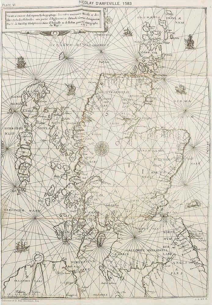
Drawn following a voyage James V took to the limits of his dominions in 1540, a copy of the first printing, made in 1583, sold for £55,000 (plus 25% premium) on February 19. The buyer was an international dealer.
Fittingly the sale of Rare Books, Manuscripts, Maps & Photographs auction was conducted by Lyon & Turnbull in Edinburgh.
Routemasters
In the 16th century this chart would have been termed a ‘rutter’ (from the French routier), the term used for a set of sailing directions. Rutters were typically secretive documents as they contained important navigational information – in this case nearly 200 observations about Scottish tidal conditions, coastal havens, sounds and hazards.
As Nicolay writes in his dedication, La Navigation… largely follows a plan drawn by Alexander Lyndsay, the little-known pilot of a voyage taken by James V in 1540 to subdue the unruly lords of the Western Isles.
It seems that a version of Lyndsay’s original manuscript map had fallen into the hands of the English politician and general John Dudley (he of Lady Jane Grey fame) who allowed Nicolay to make a copy.
The rutter was put to good use in July 1547 when a fleet of 16 French galleys navigated to St Andrews and laid siege to the castle (John Knox was among those taken prisoner). Also in 1559, when French troops were sent north in support of the regency of Mary of Guise.
That the map was finally printed in Paris in 1583 was not coincidental. It followed intrigue between the Spanish and French that mooted an attack via Scotland to put Mary Stuart (Queen of Scots) on the English throne.
Admired today for these insights into 16th century espionage and international relations, it also stands as a shining example of the age’s cartography.
Remarkably, the map remained the most precise statement of the Scottish coastline until the 18th century: more accurate than the Joan Blaeu and Robert Gordon map of 1654 or Herman Moll’s map of 1714.